Anna Ruby Falls & Unicoi State Park
 Just north of the Alpine village of Helen, Anna Ruby Falls is adjacent to Unicoi State Park. Part of the 1600 acre Anna Ruby Falls Scenic Area, the waterfalls are named for the daughter of John H. Nichols, a wealthy White County resident who owned much of the land in the vicinity.
Besides the falls, Nichols had purchased significant amounts of land around the Chattahoochee, Duke's Creek and Sautee River. The gazebo that sits on top of the Indian Mound at the junction of Highway 75 and 17 at the start of the Nacoochee-Sautee Valley was one of many area structures he designed and built.
Although the stories of the discovery of Anna Ruby Falls vary, one frequently circulated myth is that Nichols found them while riding shortly after the death of his wife and child. The falls were known as early as 1819 and are noted on survey maps of the era, long before Nichols owned the land.
Following Capt. Nichols death in 1898 the area was intensely forested. The bare earth was purchased by the United States government in the 1920's under the direction of Arthur Woody and consolidated with portions of the Cherokee National Forest in Tennessee to form the Georgia National Forest. In 1937 the name was changed to the Chattahoochee National Forest.
High atop Tray Mountain the water that becomes Anna Ruby Falls begins its journey, part as underground spring, part as runoff. The peak, on the eastern Front Range of the Appalachian Mountains (the Blue Ridge Mountains), is a popular destination for area hikers.
Mountain laurel and rhododendron constantly battle for control of the sun. White pine and poplar dominate, telling the story of the over-foresting that took place here less than a century before.

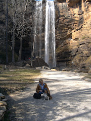
Once inside Unicoi State Park a well-marked paved road takes hikers to the trailhead. Anna Ruby Falls is a continuous, easy to moderate paved climb with bridged crossings of Smith Creek. Towards the end, there are well-placed observation decks which afford an excellent view of both waterfalls
 The path to the falls is paved, and benches line Smith Creek, which the path follows. It is a steady climb to the falls and storms have dramatically altered the walk over the last 15 years. In the early 1980's it was heavily shaded, with large trees blocking the sun. Today, because of many storms, trees have been removed and light breaks through to the ground in many places.
The rare double waterfall are formed by Curtis and York Creek from Tray Mountain which is behind Anna Ruby Falls. Fed by underground springs and runoff, the falls are a frequent stop for visitors to Helen, just a few miles south. Curtis and York were settlers who owned the land above the falls. Smith Creek, which is formed below Anna Ruby falls was named by a surveyor for an early settler who owned land further south.
Helen is accessible from the falls by foot, however, it is a long walk. Combine the Smith Creek Trail with the Unicoi/Helen Trail to make this trek.
The area here is federally managed and a modest fee is charged for parking. In addition to the falls trail, Lion's Eye is a shorter, easier interpretive nature trail that is designed for people who are physically or visually impaired. Aside from the hiking and picnicking, a visitor center and craft shop are available
Join GeorgiaTrails or login to add comments about this trail
Information by Georgia Trails - Photos by J Chandler
.
Turn your prized Landscape Photo into Canvas Art
Turn your prized Waterfall or Pet Photo into Canvas Art.
.


No comments:
Post a Comment