Amicalola Falls State Park
|

Amicalola. The Cherokee had a name for it. High in the watershed of a ridge known as Amicalola Mountain a body of water forms, enthusiastically called a river. Along the western slope the river runs, until it tumbles, swirls and drops off a ledge at the southern end of the Blue Ridge Mountains. Amicalola. Tumbling water.
This article was written in 1997. Since then the drive on GA 136 has filled in.
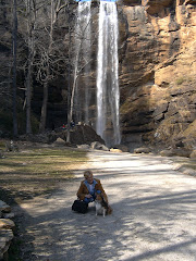
Our journey to Amicalola Falls State Park begins heading east from Jasper, Georgia, north and west of Atlanta. Not the quickest or easiest route, State Highway 136 affords the best long distance view of the falls' 729 foot tumble. It is absolutely stunning, especially in the winter when the barren trees afford the falls little cover. The waterfall dwarfs the modern lodge to right.
 |
| Amicalola Falls The winter and early spring are the best time to view the falls, although they are impressive year-round |
After a quick stop at Burt's Pumpkin Farm, it's across the street to the entrance of the park. A fee is required, and the two dollars, paid on the honor system, is well worth it. The road splits just before the visitor center. Journey to the left to get to the top of the falls and the lodge, or continue straight ahead for the visitor center and the Base of the Falls Trail.
We turn left on the Amicalola Falls Lodge Road which begins climbing immediately and a steep mile later the upper falls parking is to the right. The road follows the ridge line past this parking to the 57-room Amicalola Lodge. When the lodge was built quite a furor erupted over what critics called "the intrusive nature of the building". We stopped and walked the interpretive path along the ridge top south of the lodge. An easy hike, the trail is signed and lit at night, and it affords great views of the cove below and the Amicalola Watershed beneath the falls.
Between the lodge and the falls, stone steps rise from the road. This is the start of the Southern Terminus Trail.
Parking on the west side of the falls is limited, however, an expansive overflow parking area is available on the east side. The area here has been repeatedly raked by weather over the last five years including an unnamed rainstorm, a blizzard commonly called the Storm of the Century and Hurricane Opal.
Much of the upper observation deck and path have been rebuilt because of the storms. The deck crosses the creek, jutting out over the dramatic drop in the falls. From the deck, the foothills of the Southern Appalachian Mountains (technically, The Dahlonega Uplands) spread across much of the view, which is exceptional in the fall. About halfway down the mountain a new lot allows visitors to see the falls cascading down the mountain.
The Cherokee controlled the area until they were forcibly removed from the state of Georgia in 1838 during the "Trail of Tears." Describing the falls in 1832, William Williamson wrote:
In the course of my route in the Mountains I discovered a Water Fall perhaps the greatest in the World the most majestic Scene that I have ever witnessed or heard of the Creek passes over the mountain & the fall I think can't be less than Six hundred Yards. The Mountain is a least three fourths of a mile high. I made great exertions to get on the summit but the ascent was so great that I was completely exhausted by the time I reached half way. My position was such that I had a perfect view of the entire Fall The Steam is Called Um-ma-eolola from the Fall (Sliding Water)
Hardwoods dominate the local forest. The river forms the Amicalola Watershed, which drains into the Etowah River further south. The mountain is the southern limit for the eastern milk snake. Occasionally rare animals such as the pileated woodpecker (like Woody) and plants like the pink lady slipper are found.
Returning down the mountain, turn left at the end of the road to continue to the Base of the Falls Trail. Limited parking is available at the trailhead (at the visitors center), but parking along the road to the base augments it. The path continues to the reflection pool and winds up the cove to the observation deck at the top of the falls, although the path requires a good deal of step climbing. The path is paved in the area of the falls and is moderate.
The Visitors Center is recently remodeled and expanded.
Amicalola State Park
As far as a hiker is concerned, Amicalola could be Cherokee for hiking instead of "Tumbling Waters" (its actual meaning). This almost 1,000 acre park features 12 miles of completely integrated trails that can form a number of loop trails, and is the start (or end, depending on how you look at it) of the 2,108 mile Appalachian Trail. In addition to camping and a lodge, Amicalola Falls manages the "Hike Inn", a hiker's lodge that requires a 5 mile trek.
About the park
The first written account of the falls, by William Williamson as he explored the Cherokee Nation in anticipation of Georgia's Sixth Land Lottery includes dramatic testimony to the difficulty of the climb. Halfway up he quit.
The land was divided and given to settlers that year. Three years later Andy Jackson's administration negotiated the corrupt Treaty of New Echota, finally forcing the Cherokee from their land illegally in 1838 in an episode now known as the Trail of Tears (another Trail of Tears page)
So rugged and remote was the land in the vicinity of the falls that even the hardy settlers who pushed west did not stay here. Deep inside the valley a Cherokee woman lived until the 1850's, known only to nearby settlers.
Although the tallest falls east of the Mississippi, the park was not developed until the Georgia Appalachian Trail Club (site) needed a new terminus to the Appalachian Trail in the 1950's. The old trail to Mount Oglethorpe had been repeatedly bisected and threatened by commercial development. Springer Mountain seemed like the perfect place to create a new end to the footpath that connected America's East Coast. Amicalola Falls State Park was created to give hikers a starting point near a major road.
About the trails
There are four distinct groups of trails in Amicalola Falls State Park, the West Ridge Trail complex, the East Ridge Trail, the Amicalola Falls Trail (including the Base of the Falls Trail), and a trail from the falls to Amicalola Lodge that includes an intepreted loop with scenic views. Leaving from behind the falls, the Southern Terminus Access Trail allows hikers to get to the start of the Appalachian Trail. Len Foote Hike Inn The trail to the Len Foote "Hike Inn," begins within the boundaries of Amicalola Falls State Park, actually sharing the footpath with Southern Terminus Trail. Shortly it diverges, following an interpreted trail through a unique hiking experience. The inn is run by the state of Georgia with the assistance of volunteers from the Georgia Appalachian Trail Club and the Friends of Hike Inn. The inn is only accessible by foot and requires a five-mile hike.
Additional Information
Rangers at Amicalola Falls State Park stay busy, that's for sure. Whether its' a hot summer day or freezing cold in the winter, there always seems to be something going on here...nature hikes, informative sessions on trail hazards such as snakes, or discussions about the Cherokee Indians and settlers. If you are camping here or just visiting, we strongly recommend taking in at least one of the scheduled intepretive sessions while in the park.
How to get there:
Centrally located, Amicalola Falls State Park can be reached easily from Atlanta via GA 515, the Appalachian Development Highway or GA 400. Far and away the most scenic approach is via S. R. 136 heading east from Jasper. This gives incredible long distance views of falls. From SR 515 take SR 53 east to SR 108 (look for a blue "library" sign). Follow this road to SR136, turn right and continue on SR 136 to SR 183. Turn left, then turn right on SR 52. Amicalola Falls is on the left.
A quicker alternate is to continue north to Ellijay and take S. R. 52 east. The park is on the left after the intersection with SR 186.
For those close to GA 400, take it north to S.R. 183, the Elliott Family Highway. Turn left on SR 183 and continue to the intersection with SR 52. Turn right on S.R. 52. The park is about a mile on the left.
Amicalola Falls State Park
418 Amicalola Falls Lodge Road
Dawsonville, Georgia, 30534
Phone: (706)265-8888
http://ngeorgia.com/ang/Amicalola_Falls_State_Park">Amicalola Falls State Park from http://ngeorgia.com/">About North Georgia
Amicalola Falls State Park and Lodge


A beautiful lodge at the top of the mountain is popular with guests who prefer traditional hotel comforts, while the cottages and campgrounds are more rustic. For hikers who enjoy more adventure, a 5-mile trail leads to the backcountry Len Foote Hike Inn. Be sure to stop by the visitor center to see an Appalachian Trail display, nature exhibits, live animals and a gift shop.
Park Hours: 7 a.m. to 10 p.m.
Office Hours: 8 a.m. to 5 p.m.
Lodge open 24 hours - www.AmicalolaFalls.com
www.GeorgiaStateParks.org/AmicalolaFalls
Reservations (800) 864-7275
FACILITIES:
- 829 Acres
- 24 Tent, Trailer, RV Campsites
- 14 Cottages ($80-$160) -- #5 (Bottom of Falls) and #6 (Top of Falls) are dog friendly ($40 per dog, max 2)
- 4 Picnic Shelters ($40)
- Group Shelter
- 56-Room Lodge & Conference Center
- Restaurant
- 20-Room Hike Inn
- Visitor Center
- Ropes Course (group reservations only)
- Gift Shops

Thursday, Nov 26, 2009
| Experience a traditional Thanksgiving buffet with old-fashioned fun. Displays and Appalachian cultural demonstrations will be presented at the lodge. Reservations for the Thanksgiving buffet are required (space fills quickly). $5 parking. |
Saturday, Dec 5, 2009
| Enjoy musical performances and gingerbread house creations, and then go for a winter hayride. Afterwards warm up by the fire and visit with Santa. $5 parking. |


We offer thousands of products for outdoor grilling enthusiasts. BBQGuys.com was built to be the best one stop shop for your bbq needs.


No comments:
Post a Comment